Locate: Geo-Spatial Situational Awareness
A geo-spatial solution with feature-rich live mapping that delivers real-time GPS visibility and operational awareness for every mission, empowering decision-makers to act with confidence under pressure.
THE PROBLEM
The Awareness Struggle
Mission-critical organizations often struggle to maintain real-time awareness of personnel, assets, and threats during high-stress events. Reliance on radio check-ins and delayed updates creates blind spots, slows response, and increases risk for responders and the public.
Without real-time location visibility, agencies operate with dangerous information gaps — especially during complex operations where knowing where your people are shouldn't require a radio call that may never get through on congested channels.


THE SOLUTION
Real-Time Visibility. Every Responder. Every Asset.
Intrepid Locate transforms operational visibility by providing a shared, live map of all personnel, incidents, and assets. Commanders and field teams see the same real-time data, empowering faster, safer, and more informed decisions, delivering advanced situational awareness through actionable and easily consumable data sharing.
Unlike siloed GPS tools or static reporting systems, Intrepid Locate is purpose-built for law enforcement, fire, EMS, emergency management, and DOD operations — integrating seamlessly into daily workflows and critical incidents to provide clarity in the moments that matter most.
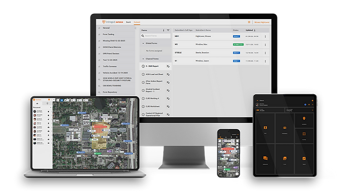
Core Capabilities
01 Live GPS Tracking
Monitor every responder's position in real time, whether on foot or in-vehicle, maintaining continuous visibility across the entire operational environment.
03 Marker Attachments
Share up to 6 files (PDF, JPEG, PNG) per marker, giving teams instant visual intelligence tied directly to locations on the map.
05 Auto-Navigation
Instantly route to personnel, assets, or incidents with one tap — reducing arrival times and improving coordination across complex environments.
07 Web + Mobile Interface
Command centers and field teams maintain a synchronized common operating picture across all devices, empowering better-informed decisions in near real-time.
02 Interactive Maps with Annotations
Add and edit markers, shapes, and perimeters instantly to define operational zones, hazards, and points of interest with real-time team-wide sharing.
04 Sensor Integration
Support for UAVs, GPS trackers, and Wi-Fi beacons to expand operational awareness beyond personnel — monitoring assets, vehicles, and environmental sensors in the same common operating picture.
06 Landscape Mode
Optimized for chest-mounted field use in patrol and tactical operations, ensuring usability in high-stress environments where hands-free operation is essential.
08 24/7 365 U.S. Based Customer Support
Intrepid Networks provides reliable, U.S.-based customer support 24 hours a day, 7 days a week, 365 days a year.
Trusted by Agencies Nationwide
No matter if you're there at the incident or not, you can see what's going on so you can prepare.
Captain Jeremy Geiger, Minnesota State Patrol
We use Intrepid Response for every tactical operation. I can't imagine going back to managing tactical operations without the useful features that Intrepid puts at my fingertips.
Commander Clevenstine, SCIT (Suburban Critical Incident Team), Waukesha County

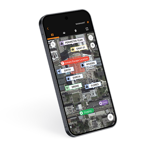
CASE STUDY SPOTLIGHT
Waukesha County Manhunt: Five Tactical Teams, One Shared Map
The Situation
Five tactical teams from multiple agencies deployed overnight during a manhunt for a suspect
The Response
Using Intrepid Locate, commanders tracked every operator in real time on a shared operational map. Teams maintained coordinated search lines while investigators marked evidence locations directly on the map.
The Outcome
Five agencies operated as a single coordinated force with complete visibility across the operation. The suspect was located and arrested without further incident.
“Intrepid Response was invaluable to the success of the operation.”
— Commander Clevenstine, SCIT
Part of the Unified
Intrepid Response Platform
Intrepid Activate isn't a standalone notification system — it's one module within the most complete, secure, and proven mission-critical collaboration and intelligence solution for public safety field operations.Mobilization, communication, situational awareness, and reporting work together seamlessly from the moment the call goes out — keeping everyone connected, coordinated, and informed.